


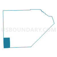
Voting District 1158674000002, Monroe County, Michigan
About
Outline

Summary
| Unique Area Identifier | 598376 |
| Name | Voting District 1158674000002 |
| County | Monroe County |
| State | Michigan |
| Area (square miles) | 27.14 |
| Land Area (square miles) | 26.89 |
| Water Area (square miles) | 0.25 |
| % of Land Area | 99.10 |
| % of Water Area | 0.90 |
| Latitude of the Internal Point | 41.77068600 |
| Longtitude of the Internal Point | -83.73177430 |
Maps

Graphs
Select a template below for downloading or customizing gragh for Voting District 1158674000002, Monroe County, Michigan


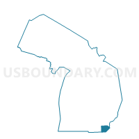
Neighbors
Neighoring Voting District (by Name) Neighboring Voting District on the Map
- Voting District 0912120000001, Lenawee County, MI
- Voting District 0916858000001, Lenawee County, MI
- Voting District 1157714000001, Monroe County, MI
- Voting District 1158674000001, Monroe County, MI
- SYLVANIA CITY 1 Voting District, Lucas County, OH
- SYLVANIA CITY 14 Voting District, Lucas County, OH
- SYLVANIA CITY 21 Voting District, Lucas County, OH
- SYLVANIA CITY 3 Voting District, Lucas County, OH
- SYLVANIA CITY 4 Voting District, Lucas County, OH
- SYLVANIA TOWNSHIP A Voting District, Lucas County, OH
- SYLVANIA TOWNSHIP AA Voting District, Lucas County, OH
- SYLVANIA TOWNSHIP K Voting District, Lucas County, OH
Top 10 Neighboring County Subdivision (by Population) Neighboring County Subdivision on the Map
- Sylvania township, Lucas County, OH (48,487)
- Whiteford township, Monroe County, MI (4,602)
- Summerfield township, Monroe County, MI (3,308)
- Deerfield township, Lenawee County, MI (1,568)
- Riga township, Lenawee County, MI (1,406)
Top 10 Neighboring Place (by Population) Neighboring Place on the Map
Top 10 Neighboring Unified School District (by Population) Neighboring Unified School District on the Map
- Sylvania City School District, OH (52,612)
- Blissfield Community Schools, MI (7,144)
- Summerfield School District, MI (4,543)
- Whiteford Agricultural School District, MI (4,330)
- Deerfield Public Schools, MI (1,809)
Top 10 Neighboring State Legislative District Lower Chamber (by Population) Neighboring State Legislative District Lower Chamber on the Map
- State House District 46, OH (127,690)
- State House District 55, MI (104,306)
- State House District 57, MI (94,159)
Top 10 Neighboring State Legislative District Upper Chamber (by Population) Neighboring State Legislative District Upper Chamber on the Map
- State Senate District 2, OH (363,296)
- State Senate District 17, MI (267,269)
- State Senate District 16, MI (253,123)
Top 10 Neighboring 111th Congressional District (by Population) Neighboring 111th Congressional District on the Map
- Congressional District 15, MI (682,205)
- Congressional District 7, MI (676,899)
- Congressional District 9, OH (619,010)
Top 10 Neighboring Census Tract (by Population) Neighboring Census Tract on the Map
- Census Tract 92.01, Lucas County, OH (7,860)
- Census Tract 82.01, Lucas County, OH (4,673)
- Census Tract 8330, Monroe County, MI (4,602)
- Census Tract 8329, Monroe County, MI (4,454)
- Census Tract 621, Lenawee County, MI (4,408)
- Census Tract 81, Lucas County, OH (3,911)